
Government of Canada
Type of resources
Topics
Keywords
Contact for the resource
Provided by
Years
Formats
Representation types
Update frequencies
status
-
Wild fish health data (length, weight, gonad size, etc.) are now available for trout perch collected from the Athabasca and Peace Rivers; white sucker collected from the Athabasca River; longnose sucker collected from the Peace River; slimy sculpin collected from the Steepbank River; lake chub from Alice Creek, the Ells and Dover Rivers; and longnose dace from the Mackay River. Contaminants data available for walleye collected from the Athabasca and Peace Rivers. For each of these data sets, upstream reference areas are provided for comparison to downstream developed sites. Reference data are currently being evaluated for variability between years to develop triggers, and these triggers are essential to eventually quantify potential effects at exposed sites. Using existing critical effect sizes developed in the Environmental Effects Monitoring programs for pulp and paper and metal mining effluents, condition endpoints in white sucker were increased within the deposit. Slimy sculpin condition and reproductive endpoints are also exceeding effect sizes downstream of development sites. This data is now being used to predict future fish health endpoints within sites, between sites and relative to reference variability to help assess change in fish health.
-
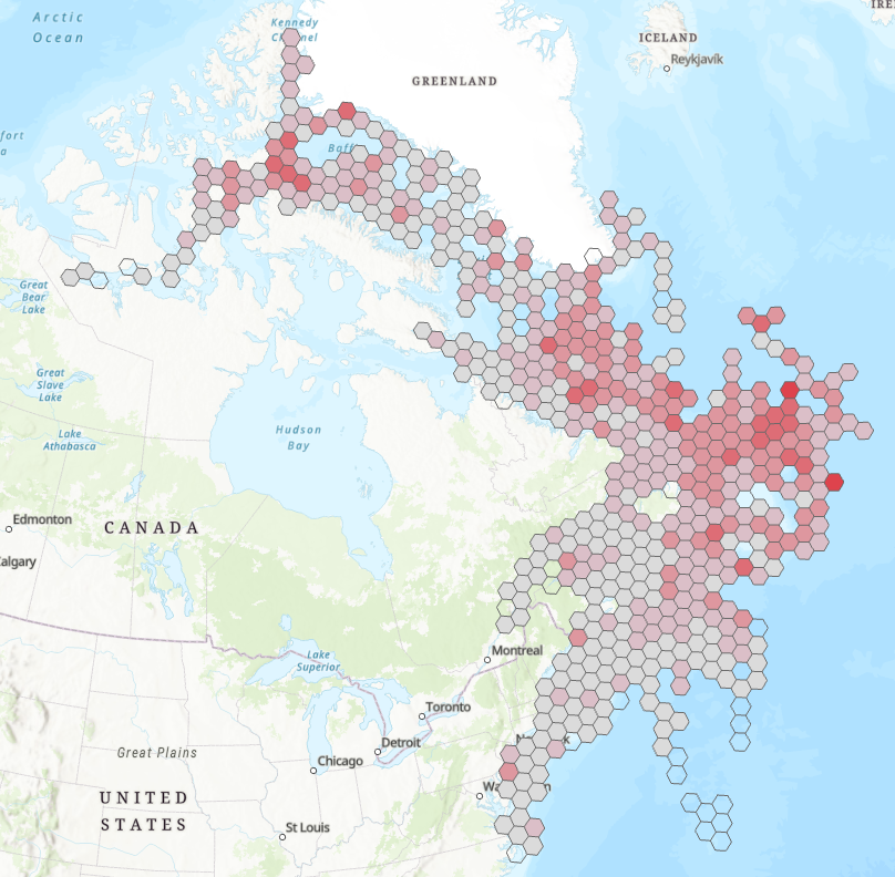
The atlas provides printable maps, Web Services and downloadable data files representing seabirds at-sea densities in eastern Canada. The information provided on the open data web site can be used to identify areas where seabirds at sea are found in eastern Canada. However, low survey effort or high variation in some areas introduces uncertainty in the density estimates provided. The data and maps found on the open data web site should therefore be interpreted with an understanding of this uncertainty. Data were collected using ships of opportunity surveys and therefore spatial and seasonal coverage varies considerably. Densities are computed using distance sampling to adjust for variation in detection rates among observers and survey conditions. Depending on conditions, seabirds can be difficult to identify to species level. Therefore, densities at higher taxonomic levels are provided. more details in the document: Atlas_SeabirdsAtSea-OiseauxMarinsEnMer.pdf. By clicking on "View on Map" you will visualize a example of the density measured for all species combined from April to July - 2006-2020. ESRI REST or WMS map services can be added to your web maps or opened directly in your desktop mapping applications. These are alternatives to downloading and provide densities for all taxonomical groups and species as well as survey effort.
-
Water level and discharge data are available from Water Survey of Canada’s Hydrometric Network. The Water Survey of Canada (WSC) is the national authority responsible for the collection, interpretation and dissemination of standardized water resource data and information in Canada. In partnership with the provinces, territories and other agencies, WSC operates over 2500 active hydrometric gauges across the country, maintains an archive of historical information for over 7600 stations and provides access to near real-time (water level and stream flow) provisional data at over 1700 locations in Canada.
-

This dataset provides marine bacteriological water quality data for bivalve shellfish harvest areas in New Brunswick, Canada. Shellfish harvest area water temperature and salinity data are also provided as adjuncts to the interpretation of fecal coliform density data. The latter is the indicator of fecal matter contamination monitored annually by Environment and Climate Change Canada (ECCC) within the framework of the Canadian Shellfish Sanitation Program (CSSP). The geospatial positions of the sampling sites are also provided. These data are collected by ECCC for the purpose of making recommendations on the classification of shellfish harvest area waters. ECCC recommendations are reviewed and adopted by Regional Interdepartmental Shellfish Committees prior to regulatory implementation by Fisheries and Oceans Canada (DFO).
-
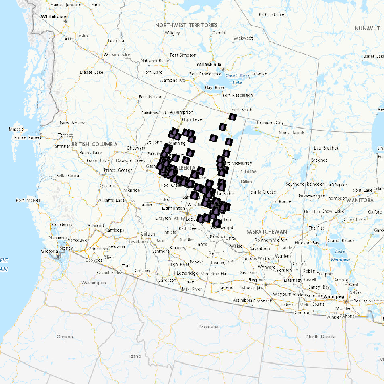
Water Quality Monitoring on Tributaries in the Athabasca River Oil Sands Region Ells River (EL1, ELLS RIFF 2, ELLS RIFF5 [2012-2015]) Mackay River (MA1 [2012-2015], MA2 [2013-2015]) Steepbank River (STB RIFF1, STB WSC, STB RIFF7, STB RIFF10 [2012-2015]) Firebag River (FI1, FI WSC [2012-2015]) Muskeg River (MU1 [2012-2015]), MU6 [2012-2015]), MU7 [2012]) High Hills River (HIHI1 [2013-2015]) Water quality of tributaries in the Athabasca River oil sands region is heavily influenced by the presence of the underlying Cretaceous bedrock, which is comprised of shale, sandstone and limestone. The waters are moderately hard (average alkalinity of 114 mg l-1 CaCO3) because of their mineral content, particularly magnesium (average 8.62 mg l-1), calcium (average 28.06 mg l-1) and bicarbonate (138.53 mg l-1). This mineral content results in an average conductivity of 245 +/- 4 µS cm-1 and total dissolved solids concentration of 140 +/- 2 ppm. Concentrations of nitrogen and phosphorus (indicators of nutrient status) are typically low to moderate, averaging 0.14 mg l-1 total phosphorus, 0.03 mg l-1 total dissolved phosphorus, 0.92 mg l-1 total nitrogen, 0.09 mg l-1 nitrogen as nitrate+nitrite, and 0.04 mg l-1 nitrogen as total ammonia. Seasonal variation for the majority of water quality constituents within the Athabasca tributaries can be strong and is highly reflective of hydrological discharge (i.e., highest concentrations typically occur during snowmelt periods, especially for parameters that are bound to particulate matter). Spatial variation of parameters within tributaries general showed an increasing trend from upstream of development to samples collected downstream of development (near mouth of a tributary). Of the 45 water quality constituents (physical characteristics, major ions, metals, metalloids, selenium) and 52 Polycyclic Aromatic Compounds (PACs) analyzed, 28 have Guidelines for the Protection of Aquatic Life (Canadian Council of Ministers of the Environment – CCME). Only a few parameters were classified with frequent exceedances (i.e., >10% of of the approximately 1430 samples): total iron, 99% of all samples; total aluminum, 61%; total suspended solids, 39%; and total copper, 17%. All measurements of total mercury were below the CCME guideline; only pyrene from the PACs showed occasional exceedances (2% of samples) for established guidelines. Exceedances of guidelines are not uncommon in many river systems within and outside of the Oil Sands region and, in general, are associated with high flow events when suspended solids and contaminant loads are the greatest. High concentrations of suspended sediment (measured as total suspended solids) were observed during high flow events, such as occur during snowmelt and summer rainfall events. The high percentage of exceedances for iron was expected as these waters are known to have naturally-occurring high concentrations of iron. Mercury in Tributaries This data set includes river water concentrations of total mercury (THg; all forms of mercury in a sample) and methyl mercury (MeHg; the form of mercury that bioaccumulates through food webs) in five Athabasca River tributaries (Ells, Steepbank, Firebag, Muskeg and MacKay rivers). No samples exceeded the Canadian Council of Ministers of the Environment guidelines for THg and MeHg.
-

This dataset provides geospatial polygon boundaries for marine bivalve shellfish harvest area classification in British Columbia, Canada. These data represent the five classification categories of marine bivalve shellfish harvest areas (Approved; Conditionally Approved; Restricted; Conditionally Restricted; and Prohibited) under the Canadian Shellfish Sanitation Program (CSSP). Data are collected by Environment and Climate Change Canada (ECCC) for the purpose of making applicable classification recommendations on the basis of sanitary and water quality survey results. ECCC recommendations are reviewed and adopted by Regional Interdepartmental Shellfish Committees prior to regulatory implementation by Fisheries and Oceans Canada (DFO). These geographic data are for illustrative purposes only; they show shellfish harvest area classifications when in Open Status. The classification may be superseded at any time by regulatory orders issued by DFO, which place areas in Closed Status, due to conditions such as sewage overflows or elevated biotoxin levels. For further information about the current status and boundary coordinates for areas under Prohibition Order, please contact your local DFO office.
-

This dataset provides marine bacteriological water quality data for bivalve shellfish harvest areas in Quebec, Canada. Shellfish harvest area water temperature and salinity data are also provided as adjuncts to the interpretation of fecal coliform density data. The latter is the indicator of fecal matter contamination monitored annually by Environment and Climate Change Canada (ECCC) within the framework of the Canadian Shellfish Sanitation Program (CSSP). The geospatial positions of the sampling sites are also provided. These data are collected by ECCC for the purpose of making recommendations on the classification of shellfish harvest area waters. ECCC recommendations are reviewed and adopted by Regional Interdepartmental Shellfish Committees prior to regulatory implementation by Fisheries and Oceans Canada (DFO).
-

This dataset provides marine bacteriological water quality data for bivalve shellfish harvest areas in Prince Edward Island, Canada. Shellfish harvest area water temperature and salinity data are also provided as adjuncts to the interpretation of fecal coliform density data. The latter is the indicator of fecal matter contamination monitored annually by Environment and Climate Change Canada (ECCC) within the framework of the Canadian Shellfish Sanitation Program (CSSP). The geospatial positions of the sampling sites are also provided. These data are collected by ECCC for the purpose of making recommendations on the classification of shellfish harvest area waters. ECCC recommendations are reviewed and adopted by Regional Interdepartmental Shellfish Committees prior to regulatory implementation by Fisheries and Oceans Canada (DFO).
-

This dataset provides geospatial polygon boundaries for marine bivalve shellfish harvest area classification in New Brunswick, Canada. These data represent the five classification categories of marine bivalve shellfish harvest areas (Approved; Conditionally Approved; Restricted; Conditionally Restricted; and Prohibited) under the Canadian Shellfish Sanitation Program (CSSP). Data are collected by Environment and Climate Change Canada (ECCC) for the purpose of making applicable classification recommendations on the basis of sanitary and water quality survey results. ECCC recommendations are reviewed and adopted by Regional Interdepartmental Shellfish Committees prior to regulatory implementation by Fisheries and Oceans Canada (DFO). These geographic data are for illustrative purposes only; they show shellfish harvest area classifications when in Open Status. The classification may be superseded at any time by regulatory orders issued by DFO, which place areas in Closed Status, due to conditions such as sewage overflows or elevated biotoxin levels. For further information about the current status and boundary coordinates for areas under Prohibition Order, please contact your local DFO office.
-
The National Pollutant Release Inventory (NPRI) is Canada's public inventory of pollutant releases (to air, water and land), disposals and transfers for recycling. This file is a geodatabase (GDB) that shows the locations of all facilities that reported to the NPRI in the current reporting year. The data are also available in a virtual globe format : https://open.canada.ca/data/en/dataset/d9be6bec-47e5-4835-8d01-d2875a8d67ff Please consult the following resources to enhance your analysis: - Guide on using and Interpreting NPRI Data: https://www.canada.ca/en/environment-climate-change/services/national-pollutant-release-inventory/using-interpreting-data.html - Access additional data from the NPRI, including datasets and mapping products: https://www.canada.ca/en/environment-climate-change/services/national-pollutant-release-inventory/tools-resources-data/exploredata.html